Algeria
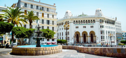
Algeria is the largest country in Africa, bordering Morocco, Mali, Libya, Tunisia, Niger, Mauritania and Western Sahara. The country has a land area of over 2.3 million square kilometres, most of which is covered by the Algerian Sahara Desert. Approximately two thirds of Algeria’s 44.6 million inhabitants [1] live in urban areas [2], primarily along or near the country’s 2,148 sq km coastline with the Mediterranean Sea. Algiers, the capital city, hosts a population of over 3.5 million.
While most of the country is characterized by an arid climate, Algeria’s northern region contains fertile plains, mountain ranges and basins. Because cities have primarily been formed in Algeria’s northern region, urban growth was seen as a threat to agricultural lands there. To prevent further encroachment of cities onto productive soil, governments began a long process of encouraging settlement development away from the coast. The process was successful, with the proportion of coastal settlements declining from 50 per cent of all settlements in Algeria in 1860 to 24 per cent in 1960, and further dropping to only 6 per cent since independence in 1962 [2].
The territory of Algeria is divided into 48 wilaya (provinces) that were created after independence, with boundaries redrawn in 1974. The wilaya are divided into anywhere between three and 21 daïra (districts), some of which serve as administrative, healthcare and service centers. Algeria has 1,540 baladiya, which are townships or municipalities similar to communes in France that establish urban boundaries throughout the country. Around 4,500 agglomerations of at least 500 inhabitants exist in Algeria, with those consisting of at least 5,00 inhabitants considered urban. These agglomerations are often merged, with their official boundaries shifting with each census [2].
Legal and Institutional Framework
After independence, three key pieces of legislation related to urban and town planning were implemented:
the 1974 Order on the creation of land reserves for the benefit of municipalities,
- the 1975 Law for establishing a cadastre,
the Order of 1976 on expropriation of land for public interest, aimed at avoiding urban crowing and preserving the country’s agricultural potential.
The 1989 Constitution of the People’s Democratic Republic of Algeria [3], as amended by the reforms of 1996, lays out basic rights related to land and property.
Article 17 declares all public property as belonging to the national collective. This includes the everything below land, mines and quarries and natural resources including energy, minerals and those found in national maritime areas, waters and forests.
Article 52 guarantees the right to private property and the right to inherit property. It also recognizes 'waqf’ properties, stating that the purpose of such property is protected by law.
Article 66 affirms that every citizen has the duty to protect public property and to respect property belonging to others.
Article 122 lays out the specific jurisdiction of the Parliament, which has the right to legislate in several land-related domains: environment, living space and land management; forests and grazing lands; water; land; mines and hydrocarbons; protection of fauna and flora; civil, trade and property obligations; property transfer from public to private sector; personal and family status including inheritance; and territorial allotment of the country.
However, legislation governing land transactions in Algeria is still limited [4].
In 2014, the Government of Algeria began developing a new urban policy that focuses on the construction of housing to meet growing demand [5]. The policy is based on three national and international roadmaps:
National Scheme of Land Planning 2030: adopted in 2010, this planning instrument focuses on sustainable development and socio-economic equity. Its aim is to strategically develop urban areas to ensure sustainability, balance, attractiveness, competitiveness and territorial equity.
Law No. 06-06: this law specifies the general principles of urban policy to be adhered to in city planning: coordination and consultation; proximity management; human development; sustainable development; good governance; information; culture; preservation; and social equity.
Millenium Development Goals (succeeded by the Sustainable Development Goals): these international norms aim to ensure the right of every person to acquire decent housing, including the most vulnerable populations, such as the poor, the unemployed, divorced women, orphans and the elderly.
Based on the guidelines laid out in these three frameworks, and with coordination between all stakeholders, the Government of Algeria aims to effectively address issues related to land and housing in urban areas. The government aims to consolidate the efforts of different sectors to implement the three main features of a policy for qualitative management of urban spaces, namely:
Establishment of a legal and regulatory framework to support its urban policy, related to management and development of urban spaces.
Revitalization and development of cities in a way that improves quality of life for citizens.
Creation of new cities and major integrated urban centres.
Land Tenure
Prior to France’s colonization of Algeria, there were two main types of land tenure in the country: ‘milk’, which describes private land ownership, typically by peasants or traders and governed by Islamic laws, and ‘arch’, which describes collective land ownership by agro-pastoralists, governed by customs of local tribes [4]. With colonization in 1830 and the resulting appropriation of Algerian land, the French introduced a new set of rules based on the Napoleonic Code, which introduced property and land tenure regime more similar to that of France [6].
Traditional pastoralist lands in the Algerian steppe were collectively managed by Arab tribes, while those in the mountainous areas to the north were managed by Berber pastoralists [7]. While the French colonial regime recognized tribal rights to collective lands [4], the agricultural reforms implemented under colonization, between 1830 and 1962, resulted in an upheaval of pastoral spaces. Technological modernization and economic liberalization impacted customs and traditions, increased the extent of cropland and largely excluded pastoralists. This resulted in the decline and marginalization of customary institutions, abandonment of nomadic ways of life and land degradation in rangeland areas [7].
After independence, the Algerian government implemented a number of land reforms. Between independence and the beginning of the 1980s, reforms were taken in a socialist political context, and have been more neoliberal in nature since the 1980s [8]. As one of the first post-independence land reforms, Algeria nationalized lands that were left vacant by the exodus of French colonizers, via decrees in March 1963 [4]. State farms were then created through the process of autogestion (self-management), whereby 17,000 former colonial farms (amounting to 2.3 million hectares of land, mostly located around cities in the north) were amalgamated into 2,200 estates and given to collectives made up of former workers and supervised by government officials [8]. A significant portion of land – 5.4 million hectares, more than 70 per cent of total arable land – remained in private sector control [8].
Additional land reforms occurred after the agrarian revolution in 1971, whereby the state nationalized all communal lands, communal tribal lands (largely rangelands) and habous (religious endowments), amounting to 1.3 million hectares [8]. The 1972 law also introduced a framework for private property [6]. The state also nationalized land belonging to absentee owners and part of the land of large-scale farmers, totalling half a million hectares, and regulated access to rangelands [8]. Much of this nationalized land was re-allocated to some 900,000 landless peasants and farm workers, organized into 35,000 cooperatives, each on average 200 hectares in size [8][6]. In 1982, toward the end of the first stage of land reforms, self-managed estates and some cooperatives were consolidated into 3,400 socialist agricultural estates, each on average 730 hectares in size, totally nearly 2.5 million hectares [8]. Another 700,000 hectares of cooperative land was partitioned into plots that were allotted to members of the cooperatives, who were given individual use rights [8].
The 1996 amendments to the Constitution and subsequent legislation made private land ownership central to Algeria’s land tenure system [6]. A 2010 law allows for the sale of the rights to use some public lands, though fixed leases remain prohibited (though these are still the most common), and there is no text regulating tenancy contracts. [9]
Approximately 60 per cent of private land is not legally registered and therefore without a land title [9]. Most private sector land transactions are informal. This is typically due to one of three circumstances: 1) there is no land title for the land in question, as it has not been registered; 2) the land is owned by multiple landowners (joint possession), which complicates the transaction; 3) the land being sold or leased is actually public land, making its sale or lease illegal or restricted [9]. Joint possession of private land is possible based on family law, and 43.6 per cent of farms on private land, amounting to 63.8 percent of all private land, is held in joint possession [9].
Land registration and administration system
Decree 75-74 of 12 November 1975 governs the development of the cadastre system and the institution of the land register, which relates only to privately owned lands [11]. Algeria’s National Agency for Cadastre, headquartered in Algiers under the Ministry of Finance, was established in 1989; it also consists of five regional offices [10]. Development of a digitalized mapping system, intended to complement and integrate with the land title information database, began in 1993 [12]. Within the first ten years after its establishment, 50% of the urban cadastre had been completed [10]. A GIS system was later introduced which facilitated the ability of the national agency for cadastre to share data with other government institutions [10]. The number of properties registered nationwide rose by 30% between 2022 and 2023 thanks to improvements in speed and efficiency [13].
Land Use
More than 80 per cent of land in Algeria is covered by desert, 17 per cent by agricultural land and three per cent by arable land [6]. The vast majority of agricultural land is under meadows or pastures [15]. There are also major deposits of oil and natural gas beneath the Algerian Sahara, which contributes to the country’s economic wealth [16].
There are more than one million farms in Algeria, accounting for more than 8.4 million hectares as of the 2001 agricultural census. Of the total population only 26.8 per cent live in rural areas [6]. More than half (52.3 per cent) of these farms are less than five hectares in size, 31.7 per cent are between 5 and 20 hectares, 10.6 per cent are between 20 and 100 hectares and only five per cent are over 100 hectares in size [9], with the average farm size being 8.3 hectares. Smallholders hold only 10 per cent of farmland in Algeria [6]. Informal privatization and individualization of rangelands in the steppe is becoming common due pressures associated with population growth and contributes to over-exploitation of those lands [9].
The urban population in Algeria is growing rapidly, increasing from just 31 per cent of the total population in 1966 to 66.3 per cent of the population in 2008 [5]. Likewise, the number of urban areas in the country has also increased to accommodate this population growth, rising from 95 units in 1066 to 751 units in 2008 [5]. Most of the urban population (63 per cent) reside in the northern region on just four per cent of the Algeria’s total territory; 28 per cent of people live in the highlands, while only 9 per cent live in the south, spread out over 87 per cent of the country’s territory [5].
Pastoral communities in Algeria began the process of sedentarization during the time of French colonization, but this process has increased since the 1980s when laws supporting informal appropriation of land were enacted [7]. Since the early 2000s, some pastoral areas have been converted to agricultural use, with cultivated areas in the steppe tripling since the 1970s from one to three million hectares [7]. This has resulted in land management and demographic changes in the wester steppe, including significant population increases in places like El Bayadh, where the population grew from 47,500 in 1966 to more than 330,000 in 2018 [7].
The creation of ecologically protected areas, also since the 2000s, has also led to the appropriation of some collective rangelands [7]. In total, approximately 40 per cent of the steppe is now subject to a state-enforced regime that prohibits livestock grazing for several years at a time in an effort to allow for recovery of vegetation and combat desertification; the land is then leased for three months each year to local tribes for grazing a fixed number of animals per hectare [7].
Land Development
In 1983, the government of Algeria launched land development programs in the arid regions (the steppe and the Sahara) which included economic and legal incentives to attract private national operators [9]. Access to public land was provided through a new legislative regime, beginning with the 1983 “Access to agricultural land ownership through development” (APFA) law which granted private property rights to farmers who developed steppe or desert land that had not yet been developed [8]. Both small-scale and large-scale developments were available, for lands of between two and 10 hectares and 50 to 5,000 hectares, respectively [8]. By the time APFA ended in 2018, 1.3 million hectares had been distributed to 157,861 people, though only 262,264 hectares was ultimately cultivated [8].
Development of rural areas is key objective for the Government of Algeria [5].
Since 1999, the Government of Algeria created a number of development programs, called the Integrated Rural Development Programs (PPDRI), to promote growth in rural areas and manage rural-urban linkages [5]. These programs are organized around four main themes:
Modernization and rehabilitation of villages and Ksour (traditional cities), including of socio-economic and cultural infrastructure for public use, to improve living conditions;
Diversification of economic activities in rural areas such as tourism, trade, artisanal and other locally developed products, etc., and making rural areas more attractive to youth and to those who initially left rural areas to migrate to cities;
Protection and development of natural resources, including forest, steppe, oases, mountains and coastal areas; and
Protection and promotion of rural heritage, including local products, developed land, historical and cultural sites and traditional events [5].
To promote the cultivation of land, including the provision of subsidies to those who wished to engage in agricultural pursuits or settle in the countryside [5][7]. The programs also included the construction of roughly 900,000 housing units in rural areas, as well as infrastructure for basic services such as education, health and social services [5].
Decree 97-483, issued in 1997, presented the opportunity for developers to access public land with 40- year concession rights [9]; in 2008, the government made 40-year concessions the sole option for private farmers to gain access to public agricultural land [8]. These programs were supported was supported by Law 108 in 2011, which provides the right to concession over large parcels of land and has resulted in increased competition over land and increased risk to the longevity of traditional collective land and resources [7].
Land Disputes
Land disputes in Algeria arise from a number of issues. In agricultural areas, they are often the result of increasing conversion of agricultural land to urban land in the northern regions and conflicts between agriculture and related irrigation development and livestock farming in the steppe [9]. Circulation of false land titles resulting from the expanded real estate market (after large plots of state-owned land was partitioned) is also a major source of land conflict, with more than 36,000 false title court cases pending as of 2008 [17]. Formal courts adjudicated land disputes in Algeria [18], though in most cases people prefer to settle land and property conflicts privately before resorting to the courts, including through ‘extra-legal’ means (exchange of money, pressure, threats, etc.) [20]. Under APFA, the “Access to agricultural land ownership through development” law, which ended in 2018, people also had an option to use formal governmental mediation services [21]. When a dispute is brought to court, rulings are based on the grounds of the legally authenticated documents presented [21].
Like many other countries in the region, inheritance disputes over land tenure are also prevalent. Traditionally, local disputes were resolved according to ‘urf, or customary law, which consists of encoded verbal rules and agreements [19]. Today, Algerians draw on this oral customary law, Islamic law and statutory law in resolving land disputes related to inheritance [19]. While these different forms of law are often in conflict, leading to “forum shopping” by some, they also have the potential to be used harmoniously, depending on the knowledge and inclination of the presiding judge [19].
Land Value
The cost of urban properties in Algeria is quite high. According to the Centre for Affordable Housing Finance in Africa (CAHFA), the average price per square meter for an apartment in Algiers rose by 20% between 2016 and 2017. A moderately-priced apartment in Algiers costs 15 times the equivalent of the average annual income of a dual-income household, making property ownership out of reach for most Algerians. Real estate in Algeria is, however, in a transitional stage, as the development of large public housing projects are forcing prices in the private market to adjust [14].
Women and Land
According to the Constitution and Article 674 of the Civil Code, women in Algeria have the right to own, control and personally manage property, granting women and men the same right to buy and sell property that they have inherited or otherwise acquired [22] [24], and Article 38 of the Family Code states that a wife has the right to freely dispose of her goods [23]. However, according to Article 39 of the Family Code, a wife is required to obey her husband, which in practice restricts a woman’s right to dispose of her income and assets independently [23].
In terms of succession, the Family Code provides much lower shares of property for women then for men, a mere 1/8 for a widow with children or 1/6 for the childless widow in the case of death of the husband, and only half the brother’s share in case of death of the parents [24]. The provisions of the Family Code for widows are based on a fear that allowing a widow to inherit land will lead to it being passed to another man (assuming the widow will remarry) [24]. In the case of parental death, a sister would often relinquished even their lower shares of land and property so as to stay in good standing within the family, which might be expected to support her in the case of widowhood or divorce [24]. However, many Algerian families increasingly circumvent these inheritance laws to equally distribute land to male and female children, indicating that Algerian society is adopting more egalitarian values [23].
Women residing in rural Algeria are active in the agricultural sector, desiring autonomy and prosperity. More than 100,000 women hold a female famer’s card, and 7.5% of these women are head of holding of plots between 1 and 5 hectares in size, representing nearly one quarter of all 7 million Algerians who live on farms [24].
References
[1] Office National des Statistiques (2020). Démographie Algérienne.
[2] Algeria Country Report. Africopolis.
[3] Constitution of Algeria (1989, amended 1996).
[4] El-Ayachi, Moha, Lahcen Bouramdane, and Mouastapha G Tine (2018). "The Land tenure in Northern Africa Challenges and opportunities." African Journal of Land Policy and Geospatial Sciences, 1(1), 21-32.
[5] Government of Algeria (2014). National Report on Housing.
[6] Bertini, Rafaelle, and Abdallah Zouache (2021). "Agricultural land issues in the Middle East and North Africa." American Journal of Economics and Sociology 80(2), 549-583.
[7] Bencherif, Slimane, Mohamed Boumedienne Dahmani, Daniel Burgas, and Pablo Manzano (2021). "Current social and rangeland access trends among pastoralists in the Western Algerian steppe." Land, 10(7), 674.
[8] Colin, Jean-Philippe, Ali Daoudi, Eric Léonard, and Emmanuelle Bouquet (2021). "From formal rules to local practices: a comparative perspective between Algerian and Mexican land reforms." Land Use Policy, 101, 105120.
[9] Daoudi, Ali and Jean-Philippe Colin (2016). "Land policy and land markets on the agricultural frontier in arid Algeria." The 17th Annual Land and Poverty Conference 2016: Scaling up Responsible Land Governance, 1-26.
[10] International Federation of Surveyors (FIG) (2000). Appendix (Country Reports) to Secretaries’ Report of the Annual meeting of FIG Commission 7.
[11] Galpin, Claire. Cadastre 2014, what place for the surveyor?
[12] GPC Group (2003). Algeria National Cadastre Overview Assessment.
[13] El Moudjahid (13 January 2024). Domaine national: hausse de la délivrance des livrets fonciers de 30%.
[14] Oxford Business Group (2018). Algeria continues its housing drive.
[15] Statista. Distribution of agricultural land use in Algeria in 2020, by type.
[16] The European Space Agency (2012). Earth from Space: Algerian Sands.
[17] Parks, Robert P. (2011). Local-National Relations and the Politics of Property Rights in Algeria and Tunisia. Doctoral Dissertation, The University of Texas at Austin.
[18] Parks, Robert P. (2019). "Claiming Bits and Pieces of the State: Squatting and Appropriation of Public Domain in Algeria." Middle East Law and Governance, 11(2): 103-135.
[19] Benessaiah, Nejm (2018). "Anomie and the Post-Colonial State: Local Justice in the M’zab." In Ed. Yazid Ben Hounet, Law and Property in Algeria, 119-141. Brill.
[20] Scheele, Judith (2018). "Dignity and Honour: Struggles over Land and Legitimacy in the Soummam Valley." In Ed. Yazid Ben Hounet, Law and Property in Algeria, 82-102. Brill.
[21] Ben Hounet, Yazid (2018). "Land Appropriation, Tenure and Legal Practices in a Steppe-like Environment (Algeria)." In Ed. Yazid Ben Hounet, Law and Property in Algeria, 103-118. Brill.
[22] Interreg Next Med (2024). Empowering Women in the Mediterranean: Insights from Algeria and Türkiye on IWD.
[23] Brac de la Perrière, Caroline Sakina (2005). Women's Rights in the Middle East and North Africa – Algeria. Freedom House.
[24] Khelifi, Ghania (24 January 2022). Rural women in Algeria: Owning a land is a blessing, keeping one is a struggle. Mediterranean Network for Feminist Information
Disclaimer
The information contained in this page is based on the body of knowledge developed by UN-Habitat, GLTN and the Arab Land Initiative’s partners. The designations employed and the presentation of the material do not imply the expression of any opinion whatsoever on the part of the Secretariat of the United Nations concerning the legal status of any country, territory, city or area, or of its authorities, or concerning delimitation of its frontiers or boundaries, or regarding its economic system or degree of development. The information may contain inaccuracies due to the data source(s) and do not necessarily reflect the views of UN-Habitat or its governing bodies.
The Algeria page is still under construction. Share with us any relevant information, resource or correction to enrich our library. Contact the Arab Land Initiative at unhabitat-arablandinitiative@un.org !
